Hiking (La Coruña): To the top of Spain and Back
Perhaps the walk that most catches the imagination however is the one that takes in Spain’s northernmost point at Estaca de Bares. Estaca draws attention not only because it is Spain’s northernmost point and the meeting place for the Atlantic Ocean and Cantabrian Sea, but also because (to most people’s surprise) it sits on a latitude north of Toulouse. North and East of Cedeira, the coastline gets steadily wilder, forming Europe’s highest sea cliffs, which are then followed by awesome rock formations off Cabo Ortegal (Los Aguillones). After the spectacular Ría de Ortigueira with the island of San Vicente in the middle, the tip of then slips somewhat less abruptly into the Atlantic at Estaca de Bares.
Dos Xtremos recommends... A Estaca (see link below), who provide guides for hiking and kayaking from their base in O’Barqueiro on the river Sor (45 minute drive from Cedeira).
We took a guide on a beautiful March day for what was to be a 4-hour trek from the port of O’Barqueiro to the Estaca de Bares lighthouse. The walk is for those with some level of fitness, with the first climb out of O’Barqueiro the most difficult of all. Once you leave the paved road above the village, a dusty track unfortunately continues past the local rubbish tip (hopefully soon to be decommissioned) and then on to what is one of Europe’s largest quartz mines. From here, what is now a grassy path leads to a peak, called Cañoles, from which you have splendid views across the Sor estuary to the East (and all the way to Cabo de Peñas in Asturias on a clear day) and to Cabo Ortegal in the west. Below you and straight ahead is the lighthouse marking the top of . The route then continues past some curious mounds, which are in fact megalithic tombs (known locally as mámoas). Now overgrown and hollow, these ancient burial chambers date from the neolithic and bronze age when tribes would bury their deceased, perhaps several at a time, often on the tops of hills like this one.
The drop down and along the west side of the peninsular is quite beautiful (particularly under the afternoon sun), with green fields ending in black cliffs with a white foaming hem. This is land that was actively cultivated as recently as 30 years ago, and just below the village of Vila de Bares you can still see a series of tiny watermills built into the sloping terrain to harness the force of a stream no more than two feet wide that tumbles into the Atlantic below. Three of the original six mills still stand, with their grindstones and intricate channels that funnelled the water still perfectly in tact.
Not far past the mills the path brings you back to the paved road that leads to the lighthouse.
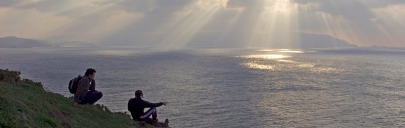
With reason, the lighthouse at Estaca de Bares is regarded as one of Europe’s most important (manned not by one lighthouse keeper, but two!): the meeting place of the Atlantic Ocean and Cantabrian sea, the wind passing this point averages force 5 throughout the year with at least a force 4 breeze six days out of ten! And, of course, you will often find a lot more wind than this. For those ships sailing west, this is just the beginning of the perilous stretch of coastline that marks the corner of Spain and is known as the Costa de La Muerte (Coast of Death). In ancient chronicles, Greeks Romans, and those before them, all wrote about the increasing difficulty of sea conditions as they rounded this point. There is something about sitting on a rock looking at a foaming sea that is good for the soul, and sitting on the rocks below the lighthouse at Estaca, watching how giant swells engulf what is known as the Estacín (the final rock showing above the water) is well worth the four hour hike!
We were picked up at the lighthouse and driven back to O’Barqueiro because it was getting late, but for the return trip add another two hours and you will take in another series of water mills, an abandoned U.S. base (hopefully soon to be dismantled), an observation point for tracking migrating birds, and the old Phoenician port of Bares.